Strong intel is a must-have for good decision making. In Macomb County, technology plays a key role in filling that need. The Macomb County Department of Planning & Economic Development is utilizing some pretty powerful tools to make sure our clients and the public have the best, most accurate and up-to-date information available when making decisions. This includes taking advantage of the latest trends and data available in Geographic Information Systems (GIS).
GIS has probably impacted your life, without you ever knowing it. GIS impacts the roads you drive on, the local parks you visit, the quaint downtowns you spend your weekends at and much more. GIS can create smart and efficient locations through leveraging and analyzing data to encourage sound and stable decision making throughout multiple departments and within local government. Macomb County is not only a smart county through advocating the power of GIS, but it is on the front end of promoting and sharing this cutting-edge technology.
 The utilization of GIS in Macomb County is happening from every stage of the workflow throughout the county. One way is through the collaboration of numerous departments and the GIS team to advance data quality and data management, for example, ensuring and improving address data for the Emergency Management Department. Another way is by providing open and free data to the public on Macomb County’s GIS Portal. A creative way Macomb County is encouraging GIS is through developing custom interactive web maps, web apps and story maps that make it easier than ever for citizens to engage with spatial data and to learn more about a variety of subjects in Macomb County.
The following are recent projects that have been improved through the power of GIS:
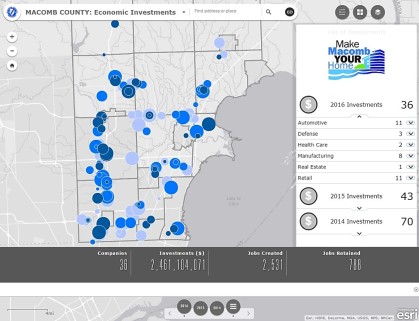
The Macomb Orchard Trail story map, which highlights all of the trail’s assets, nearby attractions and any other additional information a trail-goer might need. The Local Shops web app features 1,600 unique businesses in Macomb County, embracing the shop local and shop small initiative. Another project is the Economic Investments web app which focuses on investments in Macomb County. This web app allows the user to analyze, manipulate and visualize the data in a variety of ways through the interactive counter, summary list and graph widgets. There are more interactive web maps, apps and story maps coming soon!
For now, check out Macomb County’s GIS Portal to explore other featured web maps, open data and to learn more about GIS!
 Jessica Worley is a GIS technician for the Planning and Mapping Serices Group of the Macomb County Department of Planning & Economic Development.
